The unveiling of the first oceanographic atlas of the Persian Gulf and the Sea of Oman during the research week
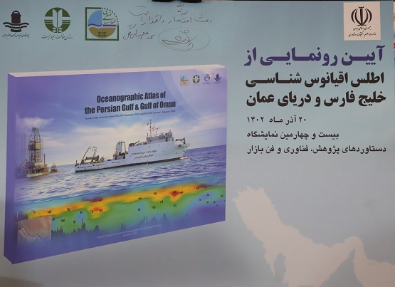
It took place at the same time as research and technology week;
Preparation of oceanographic atlas of the Persian Gulf with investment ۸ Billion/ preparation of digital version for researchers
The Vice President of Research and Technology of the National Research Institute of Oceanography and Atmospheric Sciences announced the preparation of the oceanographic atlas of the Persian Gulf and the Sea of Oman, which is the result of the research expeditions of the Persian Gulf explorer and said: this atlas contains 160 Map of analysis over 42 The oceanographic parameter of the Persian Gulf and Oman Sea is that with investment ۸ A billion Tomans were prepared.
 |
According to the public relations report Research Institute and According to ISNA news agency, Ali Mehdinia, Vice President of Research and Technology of the National Institute of Oceanography and Atmospheric Sciences, referring to the publication of the Oceanographic Atlas of the Persian Gulf, emphasizing that the compilation of this map ۹ It is the year of efforts of the researchers of the National Research Institute of Oceanography, he said: This atlas contains 160 Map of analysis over 42 The oceanographic parameter of the Persian Gulf and the Sea of Oman includes new and detailed information in various fields of oceanography, which is as follows.:
* Physical parameters such as "temperature", "salinity", "density", "turbidity", "dissolved oxygen", "chlorophyll", "sound speed", "transparency depth" and "apparent oxygen consumption"»،
* Chemical oceanography and nutrients soluble in sea water including nitrate, phosphate, silicate; suspended particles in water, nitrogen in suspended particles, phosphorus in suspended particles, ratio of nitrogen to phosphorus in suspended particles, pH and total alkalinity of water, mineral carbon dissolved in water, aragonite saturation amount in water, organic carbon in water,
* Biological oceanography includes "phytoplankton such as cyanobacteria, dinoflagellates and diatoms floating in the water column", "bed-dwelling amphibians including crustaceans, molluscs and worms" and "a group of marine mammals such as dolphins"»،
* Geological oceanography includes the parameters of particle size distribution, origin, color, gender, amount of organic matter, amount of carbonate in the surface sediments of the sea bed,
* Pollution in sediment includes heavy metals such as nickel, cobalt, chromium, copper, zinc, iron, arsenic, vanadium and lead.
* Organic pollutants include polycyclic aromatic hydrocarbons, polychlorinated biphenyls, petroleum hydrocarbons, and total nitrogen and different forms of phosphorus in surface sediments..
According to him, the route of these studies from the mouth of Arvandroud in the Persian Gulf to Chabahar in the Sea of Oman in hot and cold seasons, in total 67 station during the summer cruise and 76 Stations were surveyed during the winter trip for data collection and sampling.
Mehdinia by stating that the data of this atlas is collected through sampling from 67 Station in the summer of the year 1400 و 76 station in the winter of the year 1400 has been prepared, stated: This amount includes ۶ A thousand kilometers is the path traveled by the Persian Gulf explorer. This vessel is the only research vessel in the country that was built by the Scientific Vice President and Industries Organization in the year 97 It has been delivered to this research institute.
Details of the oceanographic atlas
The Vice President of Research and Technology of the Research Institute of Oceanography and Atmospheric Sciences stated that the oceanographic atlas of the Persian Gulf and the Sea of Oman includes maps obtained from the latest oceanographic data, and noted that these data were collected within the exclusive economic scope. (EEZ) Iran is in the Persian Gulf and Oman Sea in the field of environment and oceanography.
According to him, this atlas contains more than 160 Map and image in 88 Page with dimensions A۳ And it is in English that the latest environmental status of the Persian Gulf and the Sea of Oman in the waters and seabed EEZ It shows Iran.
Referring to the history of producing oceanographic data in the Persian Gulf and the Sea of Oman, Mehdinia said: the last complete international research sea patrol in the Persian Gulf and the Sea of Oman in the years 2000، 2001 And also 2006 by the regional marine environment protection organization (ROPME) done.
He reminded: The field of these voyages included studies on pollution, biology (phytoplankton, zooplankton, crustaceans, etc.), physical oceanography and measurement of nutrients and chlorophyll, and their results, which were mainly produced by western researchers in Kuwait laboratories, were in the form of technical reports. ROPME has been published.
Mehdinia added: Several years later, the oceanographic monitoring of the Persian Gulf and the Sea of Oman through research sea patrols. PGGOOS in the years 2012 و 2013 It was carried out by the National Research Institute of Oceanography and Atmospheric Sciences and with a logistics vessel belonging to the Navy of the Islamic Republic of Iran (Nayband Float)..
He stated that in this series of patrols, data collection was done in several stages in the Iranian part of the Persian Gulf, the Strait of Hormuz and the Sea of Oman. After the operation of the Persian Gulf research vessel by the National Institute of Oceanography and Atmospheric Sciences of Iran in the beginning of the year 2018, the number ۹ Cruise since the beginning of the year 2018 Until the beginning of the year 2022 It was done in the Persian Gulf and Oman Sea.
The Vice President of Research and Technology of the Oceanographic Research Institute reminded: Some of these trips were limited to smaller areas, while others were the entire exclusive economic zone of Iran. (EEZ) covered, included studies in the field of physical, chemical, biological and geological oceanography as well as marine pollution.
New findings of researchers from the Persian Gulf and Oman Sea
He emphasized that the findings of these voyages in 3000 scientific report page (27 Vol.) was prepared, adding: This atlas aims to collect the oceanographic features and ecological features of the Persian Gulf and the Sea of Oman, according to the data of the research cruises of the year 1400, provides a comprehensive visual and informational resource for researchers, students, and anyone interested in understanding the complex dynamics of these important marine areas..
Mehdinia emphasized: These studies show that the largest accumulation of microplastics is in the vicinity of the Mand River, which is caused by the flow of this river, especially during floods, it brings pollution and microplastics from other different urban areas into the water environment..
He stated that in this atlas the spectrum of the concentration of pollution is given in different colors, adding: This atlas has been printed in a digital version and will be available to researchers soon..
Emphasizing that a part of the cost of preparing this atlas was financed by the country's environmental development fund, this oceanography researcher noted: this atlas was made with investment ۸ A billion Tomans was prepared 5.5 billion tomans from this research institute 2.5 Its billion was provided by the Environmental Development Fund.
Necessity and importance
Regarding the importance of this atlas, he explained: After the year 2006 which is the last maritime research patrol by the regional organization ROPME had been carried out in the Persian Gulf and the Sea of Oman, until now a research tour with this comprehensiveness and scope has not been carried out in the region, and this atlas can be called the first and the largest oceanographic atlas of the Persian Gulf and the Sea of Oman, whose data has been completely produced by oceanographic researchers inside the country and using the first research vessel built by Iranian experts..
He added: Hence, in addition through detailed mapping and data display of the year 1400, this atlas serves as a valuable and up-to-date resource for policymakers, researchers, and conservationists committed to the sustainable management of these vital waters..
According to this researcher in the field of oceanography, this atlas can inform the countries of the Persian Gulf and Oman Sea on Iran's ability to independently carry out all stages of oceanographic patrols and monitoring of the Persian Gulf and lead to the activation of the organization's regional cooperation. ROPME, this time with the pivotal role of Iran, which will ultimately be an effective step in protecting the marine environment of the Persian Gulf and the Sea of Oman..
It should be noted that, at the same time as Research and Technology Week, the largest oceanographic atlas of the Persian Gulf and Oman Sea was unveiled in the 24th Research, Technology and Fan Bazaar Exhibition in the presence of the Minister of Science, Research and Technology and the President's Vice President for Science, Technology and Knowledge Economy.
 |